The European Commission, in collaboration with the European Space Agency (ESA), coordinates the Copernicus programme which is designed to monitor the environment and to mitigate the effects of climate change, contributing to the management of humanitarian emergencies, natural disasters and civil security not only for European Union’s countries, but worldwide. At the heart of this program there are the Sentinel missions, providing high-resolution radar and optical images of Earth and allowing to capture its development caused by extreme climate events, environmental changes or human activities.
Flying 800 km above, satellites take the pulse of our planet by systematically imaging and measuring changes taking place, which is particularly important in regions that are otherwise difficult to access.
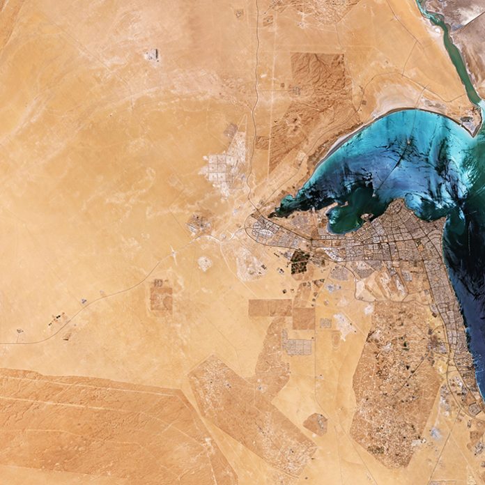
The Copernicus Sentinel-2 mission took a satellite photo of Kuwait on 25 July 2019. The image was received at the Matera Space Centre (Italy), where Italian-headquartered aerospace and defence company Leonardo – through the joint venture e-GEOS (Telespazio 80% / Italian Space Agency 20%) – acquires, processes, stores and distributes data from the main Earth observation satellites, and also produces images, products and services in near real-time.
Kuwait is generally low lying, with the highest point being only 300 m above sea level. The image shows the flat, sandy Arabian Desert that covers the majority of Kuwait and appears as a vast expanse of light sand-coloured terrain. During the dry season, between April and September, the heat in the desert can be severe with daytime temperatures reaching 45°C and, on occasion, over 50°C.
Kuwait City, visible jutting out into Kuwait Bay, holds most of the country’s population – making Kuwait one of the most urbanised countries in the world.
The various colours of Kuwait Bay come from a combination of wind and the amount of sunlight reflected off the waters. The Sheikh Jaber Al-Ahmad Al-Sabah Causeway can be seen cutting across the bay. The bridge is 36 km long – making it the fourth largest bridge in the world.
Al-Jahra lies around 50 km west of Kuwait City and is visible as a small, green oasis on the west side of Kuwait Bay. It is the centre of the country’s principal agricultural region – producing primarily fruits and vegetables. The circular shapes to the right of Al-Jahra are an example of the pivot irrigation or centre-pivot irrigation method, where equipment rotates around a central pivot and crops are watered with sprinklers.
Just south of Kuwait City lies the Great Burgan oil field – considered the second largest oil field in the world. The Great Burgan comprises three smaller fields: Burgan, Al-Maqwa and Al-Ahmadi. The oil fields can be identified an extensive network of interlocking roads which connect the individual wellheads.
For further information visit ESA webpage:
https://www.esa.int/ESA_Multimedia/Images/2020/03/Kuwait
Image – Credit: ESA, contains modified Copernicus Sentinel data (2019),
processed by ESA, CC BY-SA 3.0 IGO


