


Sulaibikhat Bay development master plan approved
The project is located within Kuwait Bay, west of Kuwait City, overlooking the coast from the Shuwaikh and Al-Rai commercial services area to the borders of Doha Port, and consists of six development areas.
-
Tender documents for the Sulaibikhat Bay Master Plan Development Project will determine the number of residential units ‘private and investment’, commercial plots, hotel rooms, and any specific development requirements.
-
The Sulaibikhat Coast area, with an area of 1,611,879 square meters and a total building area of 1,315,600 square meters, contains 17% private residential use, provided that the height of plots of land allocated for single-family villas does not exceed three floors.
The Planning Sector, led by Eng. Manal Al-Asfour, Deputy Director General of the Urban Planning Sector in the Municipality, has approved the master plan, land uses, and building ratios for the Sulaibikhat Bay Master Plan Development Project. The project is divided into six areas, according to Al Qabas newspaper.
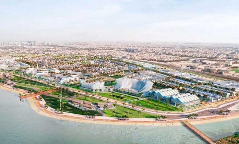
A report obtained by Al-Qabas newspaper revealed that the Sulaibikhat Bay project is located within Kuwait Bay, west of Kuwait City.
The area overlooks the coast from the borders of service sector No. 16 in the Shuwaikh and Al-Rai commercial and commercial services area to the borders of Doha Port. It consists of six development areas, in addition to the connection between these areas: “Innovation Zone – Sulaibikhat Coast Area – Sulaibikhat Sports Area – Ras Ushairj Area – Ushairj Residential Area – Ushairj Islands Area.” These areas constitute approximately 35 percent of the project site area, and this percentage also includes the restructuring of the coastline. Additionally, the proposed islands and the vacant land that can be developed in the current situation make up 29 percent of the site area.
The municipality stated that it is implementing the urban policy of the state structural plan, approved by Decree No. 255 of 2008, which is established to monitor population growth, land uses, road networks, services, and public facilities, and the resulting availability of job opportunities, in accordance with the study of the draft local plan for the third regional region, issued therein. The Municipal Council made a decision on June 24, 2013.
Regarding the building system for the development areas in the project, special ratios and heights have been determined for some parts of the project. These specifications take priority in the event of a discrepancy between them and the building system for the uses scheduled within the project.
The project area is 8,152 square kilometers, constituting approximately 35 percent of the study area, which is equivalent to 2,300 hectares, with a seafront extending 38 kilometers in length.
Innovation zone
The technical opinion stated that the innovation zone, with an area of 609,311 square meters and a total building area of 133,900 square meters, contains 32% commercial use, provided that it does not exceed a height of four floors, including the mezzanine. It also includes government facilities at a rate of 2%, with a maximum height of four floors, as well as open spaces and central suburban parks covering 42%, and roads, parking lots, and infrastructure comprising 35%.
Sulaibikhat Coast
The report indicated that the second area is the Sulaibikhat Coast area, with an area of 1,611,879 square meters and a total building area of 1,315,600 square meters. It contains 17% private residential use, provided that the height of plots of land allocated for single-family villas does not exceed three floors.
Additionally, it includes eight percent investment housing use, with the height of buildings not exceeding four floors; eight percent commercial use, with the height of buildings not exceeding four floors, including the mezzanine; nine percent government facilities with a maximum height of four floors; and four percent recreational use. Open spaces and central parks for suburbs and local parks cover 25%, while roads, parking lots, and infrastructure account for 29%.
Sulaibikhat Sports Area
The report explained that the third area is the Sulaibikhat Sports Area, covering an area of 1,707,314 square meters with a built-up area of 110,000 square meters. The area is allocated as follows: two percent for investment housing use, with building heights not exceeding six floors; 14% for government facilities; 42% for recreational use; 22% for open spaces and central parks for suburbs and local parks; and 20% for roads, parking lots, and infrastructure.
Ras Ashirj region
The report referred to the fourth region, Ras Ashirj, which spans an area of 2,725,980 square meters with a total built-up area of 1,395,500 square meters. It includes six percent commercial use, seven percent government facilities, and 23% recreational use. Hotel apartments are limited to a maximum height of four floors, including the mezzanine, while coastal resorts have a maximum height of three floors. Additionally, it allocates seven percent for nature reserves, 34% for open spaces and central parks for suburbs and local parks, and 23% for roads, parking lots, and infrastructure.
Ashirj residential area
The report addressed the fifth region, the residential area of Ashirj, covering an area of 600,995 square meters with a total built-up area of 467,700 square meters. It includes nine percent for private residential use, 19% for investment housing, two percent for commercial use, four percent for government facilities, 26% for open spaces, and 40% for roads, parking lots, and infrastructure.
Ashirj Islands
The report revealed that the sixth region, Ashirj Islands, spans an area of 896,413 square meters with a total built-up area of 292,200 square meters. It includes 11% commercial use, three percent government facilities, 32% recreational use, 38% central parks for suburbs and local parks, and 16% for roads and parking lots.
Municipality requirements
The municipality stipulated that environmental and social impact studies must be submitted separately to the Environment Public Authority for each development project proposed.
The Master Plan Department is tasked with approving detailed design plans for project areas and road networks, ensuring their integration with surrounding roads and coordinating traffic studies during licensing in collaboration with service ministries.
Projects may be proposed in stages, following established procedures and systems, and in coordination with relevant ministries and authorities as per their respective plans.
The department is authorized to relocate and adjust project shapes and areas as necessary, ensuring compliance with service ministries and regulatory requirements.
The municipality emphasized that the Master Plan Department will classify and approve commercial activities and uses (government facilities, residential, entertainment, parks, and open spaces). Special ratios and building heights have been specified for different parts of the project, with priority given to these specifications over any conflicting building systems stipulated for project uses.
Tender documents for the project will determine the number of residential units ‘private and investment’, commercial plots, hotel rooms, and any specific development requirements.