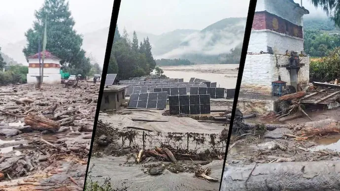
A glacial lake outburst flood (GLOF) in Bhutan has triggered flood warnings across five districts of Assam and West Bengal, raising concerns over a possible sudden surge in the Sankosh River. The flash flood has partially damaged a solar-powered irrigation project and blocked a section of a highway with debris in Bhutan, prompting precautionary measures and the evacuation of thousands of people in vulnerable areas across the Indian border. No casualties have been reported in Bhutan or the affected Indian areas.
The outburst was reported on Thursday evening at Shintaphu Lake, also known as Shintaphu Tsho, located below Wakila Mountain in Bhutan’s Gasa district. The lake lies in the upper reaches of the Mo Chhu river basin, which forms part of the Punatsangchhu river system. The river is known as the Sankosh after entering India. Any sudden release of water from the lake could therefore cause a rapid rise in water levels downstream, threatening communities along the river.
In Bhutan, the flash flood partially damaged the Solar Irrigation Lifting System serving Dochhukha-Dzomlingthang-Ritsa Chiwog under Guma Gewog in Punakha. The facility, installed earlier this year to address water shortages faced by local residents, has stopped functioning. The full extent of the damage is yet to be assessed. Floodwaters also swept debris onto a section of the Punakha-Gasa Highway in the Dzomlingthang area, disrupting the road.
Shintaphu Lake is among Bhutan’s 17 potentially dangerous glacial lakes. According to an official from the National Centre for Hydrology and Meteorology, a water-level monitoring station is located at Taktsimakhang. However, no alert had been triggered at the station when the initial reports emerged. Authorities were continuing to assess the extent of the outburst and its potential downstream impact.
Following the incident, Indian authorities issued a special flood advisory warning of a possible sharp rise in water levels along the Sankosh River. The warning covered West Bengal’s Alipurduar district and Assam’s Dhubri district, with additional alerts issued for the Darjeeling hills, Jalpaiguri and Cooch Behar districts. Authorities cautioned that floodwaters could reach the India-Bhutan border within six to eight hours of the outburst and directed district administrations to closely monitor the river and take necessary precautionary measures.
National Disaster Response Force (NDRF) and State Disaster Response Force (SDRF) personnel were deployed in Tufanganj and Boxirhat in Cooch Behar district, both located along the Sankosh River near the Assam border. West Bengal Forest Minister and Kumargram MLA Manoj Kumar Oraon appealed to residents living along the river in Alipurduar district to move to safer locations. Darjeeling MP Raju Bista also issued a public safety advisory, urging people in the catchment areas of the Sankosh and its tributaries to remain alert and evacuate vulnerable locations.
Meanwhile, authorities in West Bengal said the situation across the affected Indian areas was under control, with residents reported safe. Alipurduar Superintendent of Police Amit Kumar Shaw appealed to people not to panic, saying the police, district administration and disaster response agencies were coordinating their efforts and maintaining contact with Bhutanese authorities. He said the intensity of the water flow had decreased slightly, although a red alert remained in force for the Sankosh river system.
As a precaution, approximately 4,000 to 5,000 people were moved into temporary shelters, while more than 6,000 others were relocated to safer areas, according to the Alipurduar police chief. Eighteen relief shelters were arranged across Kumargram block, using school buildings, community halls, religious institutions and tea garden facilities. Arrangements were also made to provide dry food, drinking water, sanitation facilities and other essential supplies. Residents from vulnerable areas of Assam also moved to safer locations.
Authorities cautioned that despite the apparent reduction in the intensity of the water flow, the situation continued to require close monitoring. Officials warned that the river could carry dead fish, large pieces of wood and concrete debris, posing additional risks to people and infrastructure along its banks. Disaster response teams and district administrations remained on alert as they monitored water levels and assessed the potential impact on downstream settlements, farmland, livestock and infrastructure.