


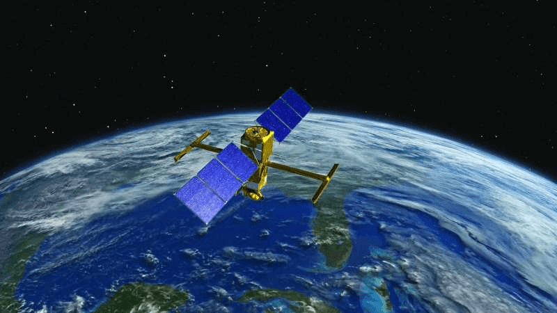
It is hoped that the French-American satellite (SWOT), which will be launched next Thursday at an altitude of 890 km, will contribute to enhancing the available information on the water cycle and providing a greater understanding of its impact on the climate, after a previous satellite provided light on the El Niño phenomenon in 1994. Its mission is to measure the surface water level of oceans, lakes and rivers
The Topix-Poseidon satellite mission is of great importance in the eyes of the French Space Agency and its American counterpart, NASA, which have been cooperating in this field for 30 years, especially since the budget allocated to it amounts to one billion dollars, reports a local Arabic daily quoting NASA sources.
This cooperation was discussed during French President Emmanuel Macron’s visit to NASA headquarters in Washington on November 30.
A SpaceX rocket launched from Vandenberg Base in California will put the giant 2.2-ton satellite into orbit. Once in space, SWOT’s mission is to measure the surface water level of oceans, lakes and rivers.
For this purpose, the satellite was equipped with a tool that is considered a revolution in this field, which is a large-scale interferometer called “KaRin”, consisting of two radars separated by ten meters, which conduct a survey of the water surface on a wide range of 120 km, which saves 2D image. The signal obtained by each of them, slightly different from that of the other, allows the determination of the level of water height.
NASA Earth Observing Director Karen St. Germain explains that the distance between the two antennas and the stability of the satellite would provide “10 times greater accuracy than current techniques for measuring ocean height and understanding how ocean hurricanes affect climate.”
As for the head of the “SWOT” project at the French space agency, Thierry Lavon, he explains, “It is like being able to distinguish the details of a car registration plate from space, while in the past it was only possible to see the street.”
This development is of great importance. If the effect of the main ocean currents on the climate is known, as is the case with the warm Gulf Stream (Gulf Stream), then this does not apply to local currents and hurricanes confined within ten kilometers, although these factors affect the temperature of the sea surface. and heat transfer, and on the ability of the ocean to absorb atmospheric carbon dioxide, explains Thierry Laffon.
This will help improve weather and climate models and monitor coastal erosion and future climate change.
“SWOT” also plays a hydrological role, as it has the ability to monitor more than 20 million lakes in terms of their height, surface area, and the evolution of the amount of water in them, and to monitor rivers that are more than 100 meters wide and calculate their flow.
Lavon expects that the data provided by the satellite will contribute to improving water resource management and preventing floods and droughts.